


Le Cheylard - Riotord

frizou83
User
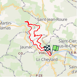

Length
12.4 km

Max alt
715 m

Uphill gradient
393 m
Km-Effort
17.7 km

Min alt
430 m

Downhill gradient
393 m
Boucle
Yes
Creation date :
2017-05-06 00:00:00.0
Updated on :
2017-05-06 00:00:00.0
4h04
Difficulty : Medium

FREE GPS app for hiking
 SityTrail
IGN / Geographical institutes
SityTrail Plus
The world is yours!
About
Trail Walking of 12.4 km to be discovered at Auvergne-Rhône-Alpes, Ardèche, Le Cheylard. This trail is proposed by frizou83.
Positioning
Country:
France
Region :
Auvergne-Rhône-Alpes
Department/Province :
Ardèche
Municipality :
Le Cheylard
Location:
Unknown
Start:(Dec)
Start:(UTM)
612723 ; 4974288 (31T) N.
Comments